Waterway Guide Logo
  • SUBSCRIBE
  • Explore
    • Explorer
    • Destinations
    • Marinas
      • Map
      • Directory
    • Services
      • Map
      • Directory
    • Anchorages & Free Docks
      • Map
      • Directory
    • Bridges & Locks
      • Map
      • Directory
    • Navigation Alerts
      • Map
      • Directory
    • Fuel
      • Diesel
      • Gas
      • Fuel Price List
  • Download The App
  • Destinations
  • Knowledge Center
  • Ship Store
    • Ship Store Home
    • Great Lakes Volume 1
    • Great Lakes Volume 2
    • Northern
    • Chesapeake Bay
    • Mid-Atlantic
    • Southern & Gulf Coast
    • Bahamas
    • Cuba
  • Urgent Alerts Urgent Alerts
  • Forgot Password?
    Or log in with:
    facebook
    apple
    Not a member? Join
Modal title

Modal body text goes here.

Log In
Forgot Password?
Or log in with:
facebook
apple

Not a member? Join
Thanks for your valuable feedback!
Back to the Waterway Explorer

View in Waterway Explorer

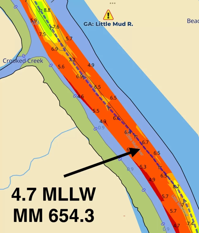
GA: Little Mud River, Shoaling MM 653.7

  • Date Reported: Dec 10, 2024
  • Reporter: Bob423
  • Source: User
  • Description:

    Update:4.7 MLLW as of 12/9/2024 on the Bob423 track except at southern end at 3.3 MLLW

    Little Mud River has been dredged but only from R194 south to just north of G197. Although the dredged depth was 12 MLLW, it has already started to shoal. The dredged channel is only 75 feet wide, and it does not follow the old channel. Those used to hugging G195 (where the deepest water used to be) will miss the dredged channel completely. North of R194, the channel is narrow and shallow as always; it was untouched. However, the bottom is very loose mud and you may not even feel the bottom when the sounder reads 0.0 MLLW but don't push your luck. 


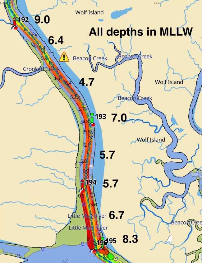
    The shallowest part of the passage is at MM 654.3 just south of Crooked Creek (top left in photo below)


    At the southern exit, pass R196 by 120 feet off.

    USACE = US Army Corps of Engineers
    ATONs = Aids TO Navigation such as buoys and daymarks
    Aqua Map = a navigation app for Apple and Android devices
    Bob423 Long Track = blue dotted line
    How to download tracks


  • Lat / Lon: N 31° 21.229' / W 081° 19.825'


Be the first to provide comments about this navigation alert

These are observations from the boating community. Waterway Guide information is verified regularly and all efforts will be made to validate any new updates submitted here. Thank you for taking the time to share comments about your experience.

Waterway Guide reserves the option of editing reviews and comments for grammar, clarity and the removal of defamatory or potentially slanderous language. When appropriate, reviews are forwarded to businesses for response prior to being made public. We will make every effort to be objective and impartial when posting reviews, but do not publicize details of disputes between parties.

Current Review Policies

Waterway Guide reserves the option of editing reviews and comments for grammar, clarity and the removal of defamatory or potentially slanderous language. When appropriate, reviews are forwarded to businesses for response prior to being made public. We will make every effort to be objective and impartial when posting reviews, but do not publicize details of disputes between parties.

  • Comments are reviewed and/or verified by Waterway Guide staff and do not post immediately. Please use a valid email address so that we can contact you if we need clarification (email address will not be published).
  • Name will be published. Anonymous comments may not be posted.
  • Comments will be shared with the reviewed marina to offer them an opportunity to respond. If they choose to do so, the marina’s comments may also be posted in response to the original comment.
  • Comments containing foul or obscene language will be rejected or returned for resubmission.
  • Comments containing personal attacks will be rejected or returned for resubmission.
  • Off-topic content will be rejected.
  • Comments must describe commenter's personal experience – “hearsay” reports will be rejected.
  • Comments must be understandable and clear enough to inform other boaters.
  • URL links are allowed only if they inform the content – no “advertising” your business or blog.

Comment on this Navigation Alert

The name field is required.

The email field is required.

  Display?

LOA is required.

Draft is required.


Yes, sign me up for the News & Navigation Alerts.

Sending...

Review Policies
  • Explorer
  • Download The App
  • Destinations
  • Knowledge Center
  • Shop
Popular Resources
Fuel Price Reports
View the Directory
Subscribe To Our Newsletter
logo
About Us
Contact
Advertise
Careers
Legal
Marina Login
© 2024 Waterway Guide Media LLC: All rights reserved. No part of this site may be reproduced without written permission.
Waterway Guide is proud to be a sponsor of:
aglca
mtoa
seven-seas
us-sailing
abm
Apple Sign-In
Note: If you already have a Waterway Guide account please choose, when prompted, to share your email with us so we can sign you in to your proper account.
Newsletter Sign-Up

A is a facility where you can keep your boat tied in a slip.

The captcha question was answered incorrectly.

The email is invalid. Please close the modal window and try again.

Signing-up...